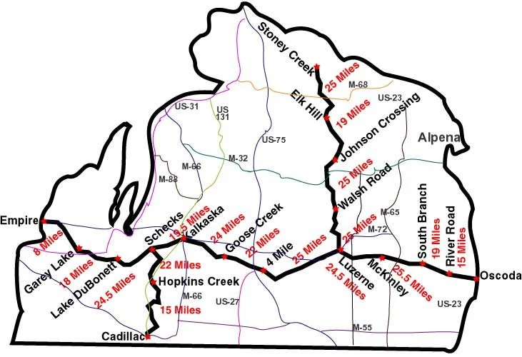
Trail Camp Maps

These camps are located along the Michigan Shore-to-Shore Riding/Hiking Trail for your convenience. Most are located 20-25 miles apart and have pit toilets and pump wells. Unless you are on an organized MTRA ride, you will need to "pay the post" and register for the days that you use the camps. It is recommended that all trail riders get familiar with our Trail Camps, how to park in camp and where the facility’s are before you arrive at camp.

DISCLAIMER:

GPS COORDINATES TO NOT TAKE INTO CONSIDERATION ROADS THAT MAY NOT BE SUITABLE FOR LARGE RIGS.

Genaric Google Map Search

North - South Camps

Stoney Creek Trail Camp
Stoney Creek Coordinates
Elk Hill Trail Camp
Elk Hill Coordinates
Johnson’s Crossing Trail Camp
Johnson's Crossing Coordinates
Walsh Road Trail Camp
Walsh Road Coordinates
Hopkin’s Creek
Hopkin's Creek Coordinates
Cadillac Trail Camp
Cadillac Coordinates

East - West Camps

River Road Trail Camp
River Road Coordinates
South Branch Trail Camp
South Branch Coordinates
McKinley Trail Camp
McKinley Trail Camp
Luzerne Trail Camp
Luzerne Coordinates
Four Mile Trail Camp
4 Mile Trail Camp
Goose Creek Trail Camp
Goose Creek Coordinates
Rapid River Trail Camp
Rapid River Coordinates
Scheck’s Trail Camp
Scheck’s Trail Coordinates
Lake DuBonnet Trail Camp
Lake Dubonnet Coordinatees
Garey Lake Trail Camp
Garey Lake Coordinates